
Dubai is known for turning ambitious ideas into extraordinary landmarks, and Palm Jumeirah is one of the clearest examples of that ambition. What began as a major land-reclamation project has grown into one of the city’s most recognisable destinations, known for its palm-shaped layout, luxury hotels, waterfront homes and impressive views of the Arabian Gulf.
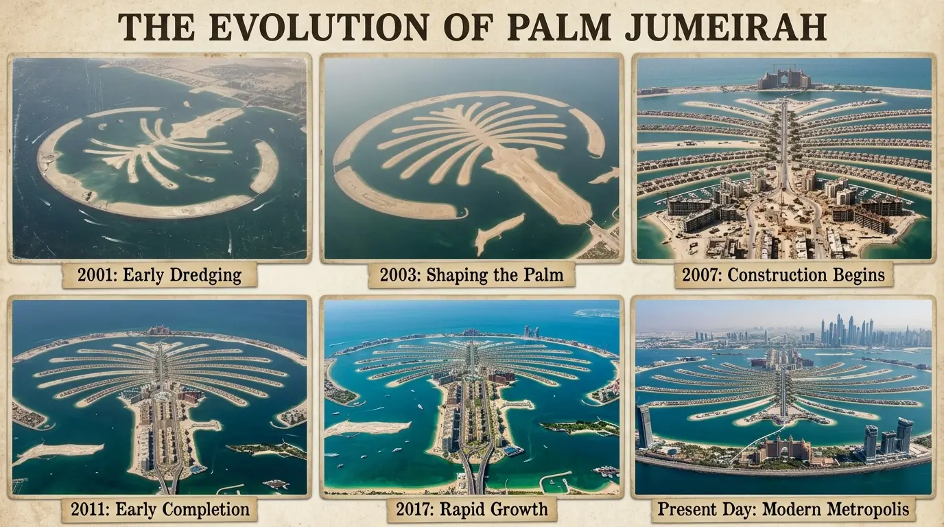
Today, Palm Jumeirah is a familiar sight in Dubai’s skyline and a popular destination for residents and tourists. But the island looked very different before construction began in 2001. Over the following years, sand was dredged from the seabed, the distinctive palm shape emerged, roads and infrastructure were added, and homes and hotels transformed the reclaimed land into a thriving destination. <Cite refs={[“turn345960search0″,”turn345960search6”]}/>
Historical photographs and satellite images offer a fascinating look at this journey. From the early stages of construction to the arrival of major resorts, these six milestones show how Palm Jumeirah developed from an ambitious engineering vision into one of Dubai’s best-known landmarks.
1. Palm Jumeirah Before Construction Began
Before Palm Jumeirah appeared on maps, the coastline looked very different. The island’s distinctive shape had yet to emerge, and the area formed part of Dubai’s natural coastal landscape.
Planning for the project took place before construction officially began in June 2001. The idea was to create additional beachfront land while developing a distinctive residential and tourism destination. It was an ambitious undertaking that would require extensive engineering and careful planning.
Early satellite images provide a useful starting point for understanding the scale of the transformation. NASA’s Earth-observation imagery documents the coastline before construction and allows viewers to compare it with later stages of development.
Looking back at this period makes the finished island even more remarkable. The familiar palm-shaped outline, now visible in aerial photographs around the world, was still a vision waiting to take shape. <Cite refs={[“turn345960search1″,”turn345960search9”]}/>
Suggested photo caption: Dubai’s coastline before the development of Palm Jumeirah began.
2. The First Signs of Construction in 2001 and 2002
The next chapter began in 2001, when construction work started on Palm Jumeirah. Rather than building the island entirely on existing land, engineers used sand dredged from the seabed to create the new landmass.
Satellite images captured in early 2002 show the first visible signs of this process. As work continued, the beginnings of the island’s distinctive shape started to appear in the Gulf.
Creating the island involved more than simply depositing sand. Engineers also had to establish the protective structures that would help shield the development from waves and the surrounding marine environment. A crescent-shaped breakwater became a defining part of the design.

The early photographs are particularly interesting because they show how the project evolved from a construction site into a recognisable geographical feature. What initially looked like a series of engineering works gradually began to resemble the palm tree that would eventually define the island. <Cite refs={[“turn345960search1″,”turn345960search14”]}/>
Suggested photo caption: Early construction work begins to reveal Palm Jumeirah’s outline.
3. The Palm Shape Emerges in 2002 and 2003
By late 2002, the palm-shaped layout was becoming increasingly visible in satellite imagery. The central trunk, branching fronds and surrounding crescent began to establish the island’s distinctive appearance.
This was a major milestone in the project’s development. Unlike a conventional waterfront neighbourhood, Palm Jumeirah was designed around a carefully planned artificial island layout, with the shape itself influencing how residential areas and waterfront properties would be arranged.
The land-reclamation phase progressed rapidly, and the island’s outline became clearer as the work advanced. According to NASA’s historical imagery, substantial progress was already visible by October 2002, while later images showed the palm form taking shape.
The development added a new feature to Dubai’s coastline and demonstrated the scale of the city’s ambitions for waterfront construction. These early aerial views remain an important part of the island’s history because they capture the moment when the original concept began to become a physical reality. <Cite refs={[“turn345960search1″,”turn345960search13”]}/>
Suggested photo caption: Aerial imagery shows the distinctive palm-shaped island taking form.
4. Palm Jumeirah’s Land Reclamation Is Completed
As construction progressed, the focus shifted from creating the island’s outline to preparing it for development. The reclaimed land needed roads, utilities and other infrastructure before residential properties and hotels could take shape.
The land-reclamation process was completed in 2003, according to The View at The Palm’s historical account, while further infrastructure and construction continued in the years that followed. NASA also documented the island’s development in satellite imagery captured during the mid-2000s. <Cite refs={[“turn345960search13″,”turn345960search6”]}/>
Photographs from this period help illustrate the difference between an island that has been physically formed and a destination that is ready to welcome residents and visitors. The palm outline was established, but many areas still had to be developed.
Road networks, access points and essential services gradually transformed the reclaimed land into a place where people could live and businesses could operate.
This stage was essential to Palm Jumeirah’s future. The island’s shape made it visually distinctive, but its infrastructure would determine how successfully it could function as a residential and tourism destination.
Suggested photo caption: The completed land formation provides the foundation for future homes, hotels and roads.
5. Residential Buildings and Hotels Begin to Transform the Island
By the middle of the 2000s, Palm Jumeirah was entering a new stage. With the land established and infrastructure developing, residential buildings and hospitality projects began changing the appearance of the island.
NASA’s satellite imagery shows buildings and vegetation appearing across the development between 2004 and 2008. Residential construction progressed, and the island began to look increasingly different from the largely undeveloped land visible in its earliest photographs. <Cite refs={[“turn345960search1″,”turn345960search16”]}/>
The arrival of residents helped turn Palm Jumeirah into more than an engineering achievement. Homes, neighbourhood roads and other facilities gradually established the foundations of a functioning community.
Hotels also played an important role in the island’s development. Atlantis, The Palm opened in 2008, becoming one of its most recognisable landmarks. The Palm Jumeirah Monorail followed in 2009, providing another transport connection for the growing destination. <Cite refs={[“turn345960search10″,”turn345960search0”]}/>
Historic photographs from this period capture a turning point: Palm Jumeirah was no longer simply a palm-shaped island rising from the sea. It was becoming a destination with homes, attractions and places for visitors to stay.
Suggested photo caption: New residential developments and landmark hotels begin to reshape Palm Jumeirah.
6. Palm Jumeirah Becomes a Recognisable Dubai Landmark
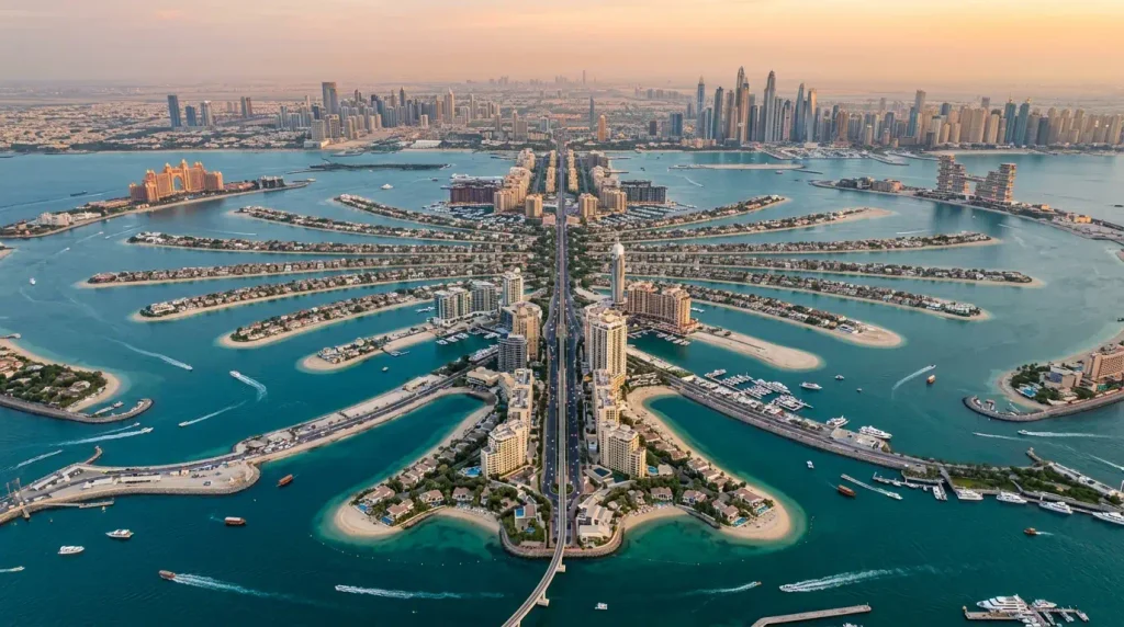
By the early 2010s, Palm Jumeirah had undergone a striking transformation. Satellite imagery captured in February 2011 showed extensive development, with vegetation across much of the palm’s fronds and numerous buildings along the trunk. <Cite refs={[“turn345960search1″,”turn345960search16”]}/>
The difference between the earliest images and those taken a decade later is dramatic. The original coastline had gained a large artificial island with a distinctive layout, residential areas, infrastructure and major hospitality developments.
Palm Jumeirah’s recognisable shape also helped establish it as a symbol of Dubai’s approach to large-scale urban development. Aerial views became an effective way to appreciate the full design, revealing the trunk, branching fronds and crescent that are less obvious when exploring the island at ground level.
The development continued beyond its initial construction period, with new hospitality, leisure and residential projects adding to the destination over time. Today, Palm Jumeirah is associated with waterfront living, beach clubs, restaurants, luxury hotels and views across the Dubai coastline.
Comparing historic images with more recent views offers a reminder of just how much the area has changed since the beginning of the century.
Suggested photo caption: Palm Jumeirah’s developed landscape showcases the scale of its transformation.
How Palm Jumeirah Changed Dubai’s Coastline
Palm Jumeirah’s development represents a significant chapter in Dubai’s urban history. The project began with land reclamation in 2001 and progressed through several stages, from forming the island to building infrastructure and developing residential and hospitality facilities.
The transformation is particularly clear in satellite imagery. NASA’s historical image series follows the island’s progress from the landscape before construction to the more developed form visible in 2011. <Cite refs={[“turn345960search1″,”turn345960search16”]}/>
The project also helped establish a distinctive waterfront destination, bringing together residential communities, hotels, transport connections and leisure attractions within one carefully planned development.
For residents who remember Dubai before the island was built, the early photographs offer a fascinating glimpse into how the city’s coastline evolved. For newer residents and visitors, they reveal the engineering and development behind a landmark that may otherwise seem as though it has always been part of Dubai.
FAQs
Construction began in June 2001, when the land-reclamation process got underway. <Cite refs={[“turn345960search0″,”turn345960search9”]}/>
The island was formed using sand dredged from the seabed, with a protective rock breakwater constructed around its outer crescent. <Cite refs={[“turn345960search6″,”turn345960search14”]}/>
NASA imagery shows the palm-shaped outline emerging during 2002, with the trunk and fronds becoming increasingly recognisable as construction progressed.
The View at The Palm records the completion of the main land-reclamation and breakwater works in August 2003. Buildings and infrastructure continued to develop afterwards.
NASA Earth Observatory and the US Geological Survey’s Earthshots archive both provide historical satellite imagery showing the island’s development over time.
Final Thoughts
Palm Jumeirah’s journey from a proposed artificial island to a globally recognised Dubai destination is a remarkable story of planning, engineering and urban development. Historic photographs and satellite images bring that story to life, showing how the island gradually emerged from the sea and developed into a place where people live, stay and spend their leisure time.
From the first signs of construction in the early 2000s to the growth of homes and hotels later in the decade, each stage contributed to the Palm Jumeirah people recognise today.
Looking back at these six milestones offers a fresh perspective on one of Dubai’s most distinctive landmarks and the dramatic changes that have reshaped the emirate’s coastline.